 How Your
 GPS
Works
Navigational Instruments - Global Positioning System
By Paul Bruno
OVERVIEW
The global positioning system is a US government owned group of assets which allow users to determine their position precisely anywhere on, or near, the earth in any weather conditions.
The system was originally designed for US military use, but became available for civilian use in the mid 1980’s.
The system uses satellites in a medium earth orbit to calculate the distance to a GPS receiver.
The distance is calculated with very accurate clocks that measure the time it takes for a signal to travel from a satellite to a receiver using the rules of relativity.
Accuracy is vital because an error of one microsecond will result in a 300 meter difference in measurement.
The user’s receiver calculates the position by comparing four or more satellite signals and calculating the intersecting point.
This is comparable to radio positioning by triangulating the common intersection of three signals, or an older example would be the navigation practice of Dead Reckoning.
GPS FUNCTION
The GPS uses three elements to accomplish transmission, maintenance, and user interface. These segments are referred to as space, control, and user.
SPACE SEGMENT
Satellites
Currently there are thirty one GPS satellites orbiting the earth in a “constellation”. The constellation is divided into six “planes”, think of them as rings around the earth.
Each plane is tilted at a different angle relative to the equator and gives the satellites different paths over the earth’s surface. Each of these planes has at least four satellites spaced along its “ring”. This allows the GPS to have four satellites in view at any time from anywhere on the earth.
The satellites have a very precise clock on board and they transmit their clock signal continuously.
CONTROL SEGMENT
Control of satellites and ground assets is accomplished with a three part control system.
Master Control Station
A master control station and backup control station monitor the condition of the satellites in orbit and space weather in the vicinity of the satellites. The accuracy of a satellite’s orbit is monitored and adjusted from these stations and the on board clocks are synchronized within nanoseconds of the control clock.
Dedicated Ground Antennas
These assets are used to measure the accuracy of data transmitted from orbiting satellites. There are four dedicated antennas with fixed, known positions. They are used as references to calibrate instruments on board satellites.
Dedicated Monitoring Stations
There are six dedicated monitoring stations around the globe. These secondary stations are used to feed data about performance to the master control station and assure the health of each satellite. Many secondary stations are necessary because transmitted signals cannot penetrate the earth, so a single station is unable to monitor all satellites simultaneously.
USER SEGMENT
The user segment is what you encounter in you daily operations.
A user segment consists of three components.
Antenna
A GPS antenna may be a single, low profile unit or may be an array of several antennas. Whether single or multiple the antenna does the same job of receiving signals from satellites in orbit and transferring those signals to the data processing unit they are connected to.
It is important to keep antennas free of obstruction or debris, most will still function but it is good practice to make sure all antennas have a good view of the sky.
Data Processing Unit
This device may be part of a display or it may be a separate device connected to a display. In commercial marine applications the GPS data unit is often located remotely from the display to avoid electrical interference, protect the unit from damage, or position the unit closer to antennas to avoid signal loss from long antenna cables.
The unit receives data from the antenna and combines the signals using a mathematical formula to determine the location of the receiver. This data is rendered into display format and sent to the display unit. The controls on the display unit may request additional information from the data processing unit.
Display
The information from the data unit is combined with other information like maps or charts and is displayed on a screen which may be a few inches across or very large and readable from several feet away. Location data might also be displayed simply in a latitude and longitude format in a separate small display.
USING GPS
Using GPS to navigate is very easy because most systems integrate the location data together with other data like electronic charts. The GPS places a vessel on the electronic chart for the viewer. Even a basic GPS provides latitude and longitude that can be recorded manually on a paper chart.
Navigation Tracking
The amount of data needed to determine a GPS location is small and can be sent to parties who need to know a ship’s position. Shipping companies, traffic monitors, and law enforcement can be informed about the location and course of a vessel for efficiency or safety reasons.
Time Standardization
Because the GPS is based on time, every GPS unit has a very accurate synchronized clock as part of its construction. This clock adjusts for time zones automatically and allows all vessels and ports to operate on a time standard. This simplifies communications and safety by synchronizing clocks and avoiding traffic congestion or confusion while lying at anchor.
More Information
GPS is a complex subject and we have only looked at it briefly. See how the GPS in your mobile telephone is different than a commercial marine system. You can also take a look at some of the physics involved in this technology.
RELATED POSTS:
.
.

Smartphone
Addiction
CLICK HERE . . . Cell Phone
Addiction:
The Ridiculous Obsession Americans Have With Their Phones
CLICK HERE . . .
 Aerosols
Tiny Particulates in the Air
CLICK HERE . . . Thrilling Speed
Why Do We Feel So Thrilled By Speed?
CLICK HERE . . .
 Pressure and Fluid
Flow
How Does Pressure Relate to Fluid Flow?
CLICK HERE . . .
..
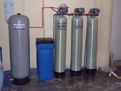 |
Multi-Media Filter, Highly-Activated Carbon Filter,
Zeolite-Process Water Softener With Brine Tank,
Fiberglass Ballast-Type Pressure Tank
(fully automatic backwash & regeneration)
|
PURICARE
Water
Treatment
Systems
.
.
...
Aganan, Pavia, Iloilo, Philippines
...
CLICK HERE . . . to view company profile . . .
CLICK HERE . . . to view company profile . . .

source: freedrinkingwater.com
 |
| Industrial Water Treatment Systems |
 |
| Water Treatment Systems for Large-Scare Poultry Tunnel Ventilation |
 |
VENTILATION AND COOLING SYSTEMS FOR POULTRY FARMS |
 |
| Tachmina Laminated Sand Filter |
No comments:
Post a Comment